

Route Description
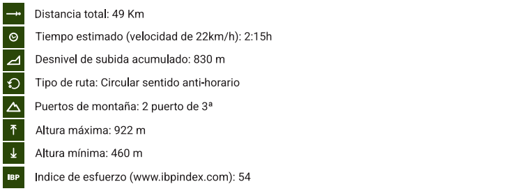
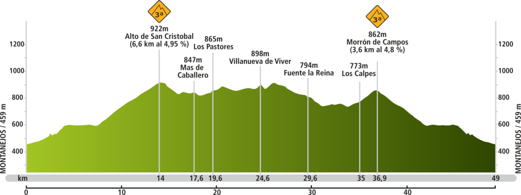
The Vuelta a la Viñaza route starts at Apartamentos Campuebla, in the Alto Mijares Cycling Center (Montanejos – Castellón), passes through Pastores, Villanueva de Viver, Fuente de la Reina and Los Calpe (province of Castellón), returning to the apartments. A total of 49 kilometers with two third-category climbs.
Route Map
We recommend using a GPS with the track for the Vuelta a la Viñaza route. If you do not have one, you can use this map on your mobile phone, and it will serve as a guide. To use it, when you arrive at the Alto Mijares Cycling Center, in Montanejos (Castellón – Valencian Community), enter the website of the route map and click on the upper right icon. When you start moving along the road, it will position you on the route.
Route Profile
In the route profile of the Vuelta a la Viñaza, from the Campuebla Apartments Cycling Center, in addition to the distance and altitude, you will find the towns you pass through, as well as the most important mountain passes, which will serve as a reference to guide you and manage your efforts.
Route Schedule
Departure from Apartamentos Campuebla in Montanejos CV20-CV208 (direction Barracas via Puerto de San Cristobal) – Villanueva de Viver CV207 – Fuente de la Reina – Los Calpes – Arrival at the Alto Mijares Cycling Center (Castellón – Valencian Community – Spain).
Track Downloads
To download the track for Route 2 Vuelta a la Viñaza, from the Alto Mijares Cycling Center, press the button for your GPS extension.
Download route 2 Vuelta a la Viñaza from the Alto Mijares Cycling Center in GPX format
Download route 2 Vuelta a la Viñaza from the Alto Mijares Cycling Center in TRX format
Download route 2 Vuelta a la Viñaza from the Alto Mijares Cycling Center in KMZ format